
Digital Photographic Recording and Construction of a 3D Computer Model of the Behaim Globe
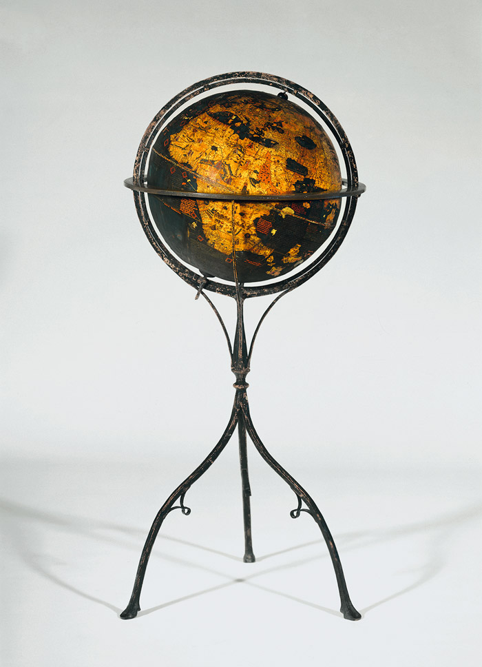
As the oldest surviving representation of the earth in the form of asphere, the Behaim Globe in the Germanisches Nationalmuseum is one of the most important cultural products in the history of geography.
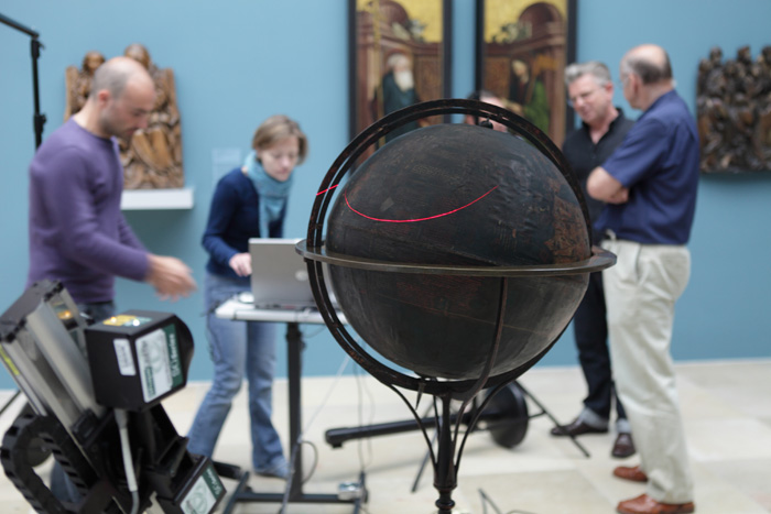
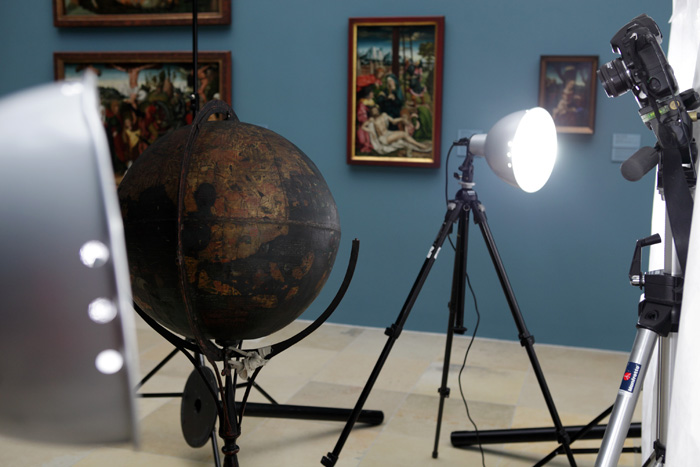
Manufactured at the same time as Christopher Columbus’s first voyage to the Americas between 1492 and 1494, the globe’s geographical map and inscriptions document the European world image on the eve of the age of discovery. With ist 110 miniatures, ca. 2,000 toponyms (place names) and numerous short and long texts, it possesses encyclopedic dimensions and considerable value as a source of knowledge about the perception of the non-European world before Columbus. The globe was made between 1492 and 1494 for the Nuremberg city council. Concept and content were provided by the widely travelled Nuremberg cloth merchant and seafarer Martin Behaim (1459-1507); the production was undertaken by the illuminator Georg Glockendon, the painter Hans Storch and the scribe Petrus Gagenhart as well as other Nuremberg specialist craftsmen. The globe initially was intended for the chambers of the Nuremberg council, the administrative centre of the municipality. Later it was moved to the “Obere Regimentsstube” (council hall) of the town hall. Until now, it has been difficult to study the globe as a whole. The latest complete edition dates from 1908 and is based on incorrect 19th-century facsimeles. Moreover, the numerous revisions, corrections and repairs of its texts have never been identified or evaluated. For these reasons, the Germanisches Nationalmuseum as the globe’s owner and the University of Erlangen-Nuremberg as project partner plan to digitize its image, making it available as a virtual 3D globe on the internet. One of the main project phases will be devoted to the production of a modern version of all texts together with critical commentary. Beyond that, the digitized image of the Behaim Globe in its three-dimensionality will set standards for similar digitisation projects and for the publication, sufficient for the concept of an “epistemic web”, of three-dimensional, culturally relevant image- and text-bearing media. In reference to this aspect, the Friedrich-Alexander-Universität Erlangen-Nürnberg is co-operating with the Max-Planck-Institut für Wissenschaftsgeschichte (Max-Planck-Institute for the History of Science) in Berlin. Furthermore, a recently formed interdisciplinary group of scholars is devoting itself to different questions concerning the Behaim Globe. In preparation of these projects, high definition digital photographs of the globe were taken in the summer of 2011 which presently are being photogrammetically processed by a team of experts under the guidance of Prof. Dr. Armin Grün, an expert in 3D-modelling at the Eidgenössische Technische Hochschule (Swiss Federal Institute of Technology) in Zurich. We are grateful to the Staedtler-Stiftung (Staedtler Foundation) for carrying the costs for the photographs taken by means of the latest digital technology and their postprocessing in the amount of approximately € 40,000.
Responsible
Dr. Thomas Eser
Roland Schewe
Partners
Friedrich-Alexander-Universität Erlangen-Nürnberg
Prof. Dr. Mechthild Habermann (Institut für Germanistik)
Prof. Dr. Günther Görz (Institut für Informatik)
Eidgenössisch-Technische Hochschule Zürich, Institut für Geodäsie und Photogrammetrie
Prof. Dr. Armin Grün
Fondazione Bruno Kessler,
Trento, 3DOM research unit
Further Impressions
Information and Services
Plan Your Visit
Opening Times
Location and Approach
GNM Museum Shop
FAQ
Library
Branches
Contact